All-day hike in Belianske Tatras is for lovers of less frequent hiking trails. This is the first part of the Tatranská Magistrála cross-over: Ždiar - Monkova dolina, Kopské sedlo - Zelené pleso. We start the hike in the village of Ždiar - bus stop Tatra. We strike out toward a junction Rázcestie Monkova dolina 0,35 h. From there we climb (sometimes steeply) along a forest path and rocky trail up until a saddle Široké sedlo. Along the way we can admire beautiful green flowering meadows and Belianske Tatras. In the valley Monkova dolina, there is also an educational trail, so we can learn interesting facts about fauna, flora and history. At higher altitudes we can very often observe grazing chamois. Upon arrival at Široké sedlo, we will see not only the Belianske Tatras, which are not accessible to tourists except for three marked hiking trails, but also the High Tatras. In the saddle, after a strenuous ascent, we can relax on a bench and continue to Vyšné Kopské sedlo, which is our highest point of the route. From here we just descend to Kopské sedlo, to a tarn Velké Biele pleso, up to the chalet Chata pri Zelenom plese, which is our goal today.
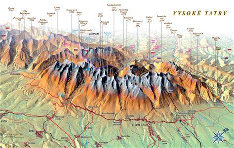
Prosiecka dolina nature reserve, Zilina. Lomnický ridge, High Tatras. Litvorové lake in Litvorova valley in the High Tatras. View of Smolenice castle in Smolenice. Dwarf mountain pine, Little Fatra mountains. Slovakia is a beautiful country with an amazing history. The people are warm and welcoming, the countryside is picturesque, and the cities have plenty to offer. Slovakia has many interesting places to visit including some of Europe's most famous tourist destinations such as Bratislava, Košice and Štúrova Vrata. The best things to do in Slovakia include visiting stunning natural sites such as the Lesser and Greater Tatra mountain ranges and exploring unique historical towns and villages. Slovakia is an extremely varied land for such a small country. Its scenery ranges from the High Tatras mountains in the north to the rich plains and the Danube Basin to the south. Slovakia's most remarkable feature, and its greatest draw, is its mountain ranges. These are part of the Western Carpathian Mountains, which extend over Slovakia’s northern and central regions. The most renowned are the High Tatras (Vysoké Tatry) along the Polish border to the north. These mountains extend in a narrow ridge from east to west and are a popular summer resort. Snow persists on the highest peaks well into the summer months and all year long in some sheltered pockets. The High Tatras are also interspersed with many deep valleys which present some of the wildest scenery. Second in fame to the High Tatras are the Low Tatras (Nízké Tatry) in central and eastern Slovakia. This is the second tallest mountain range of Slovakia. It lacks the sawtooth peaks of the High Tatras, but provides a gorgeous backdrop to the valleys. The mountains of central Slovakia give way to hills in the south-central part of the country. Across the Hron River, are the Slovak Ore (Slovenské Rudohrie) Mountains. A popular region for outdoor enthusiasts is Slovenský Raj, literally Slovak Paradise, an area of exceptional natural beauty, and of rare flora and fauna. In the west, the Little Carpathian (Malé Karpaty) range rises near Bratislava. There are distinct lowland areas in the east and southwest of Slovakia. The lowlands in the east are part of the Carpathian Depression, while those in the southwest belong to the Danube Basin. The southwest lowlands are where the country’s longest river, the Váh (269 miles), joins the Danube. The capital city of Bratislava is situated on the left bank of the Danube, and was the capital of Hungary from 1541 until 1784. It sits in a substantial region of plains which make up the country’s main farming area. Little Danube river near Zálesie, Slovakia. Over 40% of Slovakia is forest, and the trees are firs and spruce with some deciduous trees such as ash, beech and oak as well as a rich variety of shrubs. The Tatras mountains is home to stands of dwarf pine trees. In the lowlands some original steppe grassland areas also still survives, as well as floodplains and marshland. Slovakia is a haven for wildlife, especially woodland animals, such as deer, foxes, rabbits, squirrels, marmots, and otters. Slovakia has a continental climate with a sharp contrast between summer and winter. Summers are very warm, in July the mean temperature is 21°C (70°F); and winters are cool, in January the mean temperature is -1°C (30°F). Weather can vary considerably with altitude, however. Rainfall also varies with altitude. The High Tatras experiencing twice as much rain as the lowlands. Not to get lost, there are approximately 600 km of marked hiking trails in the national park High Tatras, TANAP, Slovakia. Trails have been chosen to guide to the most beautiful and interesting natural phenomena and still be safe. They head to beautiful places such as Tatra chalets, waterfalls, tarns, several peaks and saddles though Tatra valleys so do not sit at home and go hike! As a tourist you must strictly follow the rules of the Tatra national park. Also you must follow trails with marks on rocks and trees. These marks have a square shape (10 cm x 10 cm). It consists of three horizontal lines. The middle one is colourful (yellow, red, blue, green) and the bottom and upper one is white. Red mark is used for ridges. The longest and the most famous red marked hiking trail is called Tatranská magistrála, the main hiking trail. It crosses whole High Tatras in approximately the same altitude and starts in Podbanské in the west and ends in Veľké Biele pleso in the east. Blue mark is used for long-distance trails. Green mark is used for trails that guide you to other trails. There are also guideposts with approximate times to another guideposts or final destinations. Way up is more difficult and longer, way down is quicker and it can also differ from your own tempo. Moreover, there are several informational boards on the trails, they present information about fauna, flora, geology and history of the park. There are two types of trails. Ones are from asphalt for cyclists and serve for easier supply by car. Lately, a project Tatry bez bariér (Tatras without barriers) has made Tatras accessible also for disabled. More than 30 km in 8 trails are prepared. Rocks have been organized to paths or stairs to help you walk. Some places are too steep and equipped with chains to help you go up and down. Therefore, some saddles or narrow crossings are possible, recommended to pass only one way. All accessible trails are marked with colours. Ways to other upper destinations and peaks are accessible only with a booked mountain guide or if you are a climber. If you like our post, you can share it with your friends because we have more of them!